
TEMPO Interaktif, Balikpapan- Perusahaan minyak dan gas asal Prancis, Total E&P Indonesie, menyatakan produksi Blok Delta Mahakam mencapai 570 ribu minyak mentah per hari pada 2009. Jumlah tersebut merupakan produksi maksimal yang bisa dieksploitasi dari seluruh sumur minyak dan gas yang dimiliki Total Indonesie.
Subduction Zones are Potential Tsunami Locations
Cubic Feet Per Second
Cubic Feet Per Second:
A unit of measure frequently used to quantify the rate of flow of a stream. It is equal to a volume of water one foot high and one foot wide moving a linear distance of one foot in one second.Crude Oil
Crude Oil:
A liquid hydrocarbon produced from natural underground reservoirs. It might also include liquid hydrocarbons produced from tar sands, gilsonite, and oil shale. Crude oil can be refined into a number of petroleum products which include: heating oil, gasoline, diesel fuel, jet fuel, lubricants, asphalt, ethane, propane, butane, and many other products.Contour Line
Contour Line:
A line on a map that traces locations where the value of a variable is constant. For example, contour lines of elevation trace points of equal elevation across the map. All points on the "ten foot" contour line are ten feet above sea level.Contour Map
Contour Map:
A map that shows the change in value of a variable over a geographic area through the use of contour lines. For example, a contour map of elevation has lines that trace points of equal elevation across the map. See also: contour line and topographic map.Contact Methamorphism
Contact Metamorphism:
Alteration of a rock, mainly by heat, which occurs adjacent to a dike, sill, magma chamber or other magma body.Conglomerate
Conglomerate:
A clastic sedimentary rock that contains large (greater then two millimeters in diameter) rounded particles. The space between the pebbles is generally filled with smaller particles and/or a chemical cement that binds the rock together. Picture of Conglomerate.Cone of Depression
Cone of Depression:
A cone-shaped lowering of the water table around a producing well.Compaction
Compaction:
A compression process that reorients and reshapes the grains of a sediment in response to the weight of overlying deposits.Composite Cone
Composite Cone:
A cone-shaped volcanic mountain composed of alternating layers of cinders and lava flows. Also known as a stratovolcano.Coastal Plain
Coastal Plain:
An area of low relief along a continental margin that is underlain by thick, gently dipping sediments.Coal Liquefaction
Coal Liquefaction:
The process of converting solid coal into a liquid fuel such as synthetic crude oil or methanol.Coal Gasification
Coal Gasification:
The process of converting solid coal into gas, usually by heating. The gas is then used as a fuel or processed into a chemical or liquid fuel.Cinder Cone
Cinder Cone:
A cone-shaped hill that consists of pyroclastic materials ejected from a volcanic vent.Christmas Tree
Christmas Tree:
The valves, pipes and fittings installed above ground surface at an oil or gas well site. These control and direct the flow of natural gas or oil produced from the well.C-Horizon
C-horizon:
The lowest horizon of a soil profile. It is below the B-horizon and is made up of weathered bedrock.Chemical Weathering
Chemical Weathering:
The breaking down of surface rock material by solution or chemical alteration. Common alteration processes are oxidation and hydrolysis.Chemicals Sedimentary Rocks
Chemical Sedimentary Rock:
A rock that forms from the precipitation of mineral material from solution. Examples are chert and rock salt.Cementation
Cementation:
The processes through which chemical precipitates form within the pore spaces of a sediment and help bind it into a sedimentary rock.Cataclastic Rocks
Cataclastic Rock:
A breccia of powdered rock formed by crushing and shearing during tectonic movements.Carrying Costs
Carrying Costs:
The costs incurred by a lessee to retain exploration and property rights after acquisition but before production begins. Carrying costs can include: ad valorem taxes on non-producing mineral properties, shut-in royalties, and delay rentals.Carbonic Acid
Carbonic Acid:
A weak acid (H2CO3) that forms from the reaction of water and carbon dioxide. Most rain water is a very weak carbonic acid solution formed by the reaction of rain with small amounts of carbon dioxide in the atmosphere.Carbonate Rock
Carbonate Rock:
A rock made up primarily of carbonate minerals (minerals containing the CO3 anionic structure). Limestone (made up primarily of calicite - CaCO3) and dolostone (made up primarily of dolomite - CaMg (CO3)2 are the most common examples.Block Fault Mountain
Block Fault Mountain:
A linear mountain that is bounded on both sides by normal faults.Bituminous Coal
Bituminous Coal:
A rank of coal that falls between anthracite and semi-bituminous. The most abundant rank of coal. Frequently referred to by the layman as "soft coal".Bioturbated
Bioturbated:
An adjective used in reference to a sediment or sedimentary rock. Bioturbated sediments have been disturbed by animals (such as burrowing worms or shell fish) or plant roots. These have penetrated the sediment and disturbed any or all original sedimentary laminations and structures. Bioturbated rocks were disturbed in this way while still in the soft sediment phase of their formation.Biochemicals Rocks
Biochemical Rocks:
A sedimentary rock that forms from the chemical activities of organisms. Organic (reef and fossiliferous) limestones and bacterial iron ores are examples.Beta-Particle
Beta-Particle:
An electron emitted with high energy and velocity from the nucleus of an atom during radioactive decay.B-Horizon
B-horizon:
A layer in the soil, below the A-horizon, where materials leached from above accumulate. Typically enriched in clay and oxides.Bathymetry
Bathymetry:
The measurement of ocean depths and the preparation of topographic maps of the ocean floor.Batholit
Batholith:
A very large intrusive igneous rock mass that has been exposed by erosion and with an exposed surface area of over 100 square kilometers. A batholith has no known floor.Basic Rock
Basic Rock:
An igneous rock that has a relatively low silica content. Examples are gabbro and basalt. Also see entries for acidic, intermediate and ultrabasic rocks.Geologic Terms
Basement:
The igneous and metamorphic rocks that exist below the oldest sedimentary cover. In some areas such as shields the basement rocks may be exposed at the surface.Base Flow
Base Flow:
Water that seeps into a stream through a permeable rock or sediment unit that outcrops in the bottom or banks of the stream.Base Level
Base Level:
The lower limit of erosion by a stream. Sea level is the ultimate base level. However, lakes can serve as a temporary base level in upstream areas.Geologic Terms
Bar:
An underwater ridge, usually of sand and/or gravel, that forms from the deposition and reworking of sediments by currents and/or waves. Bars occur in rivers, river mouths and in offshore waters.Bank Storage
Bank Storage:
Water that seeps into the ground along the banks of a stream during a time of high flow. This loss of water into the ground slightly reduces the height that the stream will attain and then slowly seeps into the stream as the high water level subsides - hence the term "bank storage".Bankfull Stage
Bankfull Stage:
A height of water in a stream that completely fills the natural channel. If the water rises any higher a flood will occur.Banded Iron Ore
Banded Iron Ore:
A rock that consists of alternating layers of chert and iron oxide mineral (usually hematite) with the iron oxide in high enough concentration to be of economic value.Sumatra Subduction Zone

A magnitude 7.7 earthquake struck deep beneath the Selat Mentawai (Mentawai Straight), between Sumatra and the nearby Simeulue and Nias Islands on April 6, 2010. Although it was stronger than any earthquake in the continental United States since the Great San Francisco Earthquake of 1906 (magnitude 7.8), it was modest by Indonesian standards. Two recent great earthquakes—a magnitude 8.6 on March 28, 2005, and a magnitude 9.1 on December 26, 2004—occurred within 125 kilometers of the recent quake. The structure of the region’s sea floor and the topography of the islands give clues about the source of the geological violence: Sumatra is part of an island arc along the boundary where the Australia and Sunda tectonic plates collide.
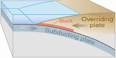
This map shows the location of the magnitude 7.7 earthquake (red star) and the series of weaker aftershocks that occurred over the next several days (red circles). The aftershocks ranged up to magnitude 5.1. The depth of the ocean is shown in blue, with darker colors representing deeper water. Elevation is shown in shades of brown; lighter areas are higher. The boundary between the Australia Plate and the Sunda Plate is a thick black line. Arrows represent the relative direction of motion of the two plates, which are colliding at a rate of about 60 millimeters (2 inches) per year. Most of the time, friction between the plates causes them to stick together, and stress increases over time. When enough stress builds to fracture the stuck rocks, the plates jump past each other, releasing energy in the form of earthquakes.
The map reveals typical features of a subduction zone: an oceanic trench, a fore-arc ridge, a fore-arc basin, and an island arc. The location of the plate boundary is marked by the Sunda Trench, a narrow band of very deep water that parallels the Sumatran coast. Along the trench (lower left), the Australia plate is moving underneath (represented by a curved arrow) the Sunda Plate, forming a deep trough. On the edge of the Sunda Plate, approximately 100 kilometers (60 miles) from the Sunda Trench and 180 kilometers (100 miles) from Sumatra, are a series of islands that are the crest of a fore-arc ridge. The ridge is formed primarily from marine sediments scraped off the top of the Australia plate and piled up on top of the leading edge of the Sunda Plate. These sediments are called an accretionary wedge.
Simeulue and Nias are separated from Sumatra by the Selat Mentawai. This sea is a fore-arc basin, a depression between the fore-arc ridge and island arc. Sediments washed into the basin from both the fore-arc ridge and island arc weigh down the crust in this area, creating the depression. Sumatra itself is part of an island arc. The island is raised above sea level by the upwelling of hot, buoyant magma, derived from partially melted rocks along the boundary between the subducting (Australia) plate and the overriding (Sunda) plate. Active volcanoes and calderas fed by the rising magma parallel Sumatra’s west coast. Among these is Toba Caldera, the site of the largest eruption in the past 2.5 million years.
Active subduction off the Indian Ocean coast of Sumatra is responsible for both the region’s geography and its earthquakes. Although rare on human timescales, over geologic time earthquakes are frequent in the area. The same forces that produce the earthquakes also created Sumatra, its volcanoes, the nearby islands, and shaped the sea floor.
References
- The Jakarta Post. (2010, April 8). Quake sparks fears of 2004 havoc repeat. Accessed April 9, 2010.
- Sieh, Kerry. (2006, June 26). Sumatran megathrust earthquakes: from science to saving lives. Philosophical Transactions of the Royal Society. 364(1845), 1947-1963.
- USGS. (2010, April 6). Magnitude 7.7 - Northern Sumatra, Indonesia. Accessed April 13, 2010.
NASA image by Jesse Allen and Robert Simmon, based on data from the General Bathymetric Chart of the Oceans, the Shuttle Radar Topography Mission, the USGS Earthquake Hazard Program, and the Sumatran Plate Boundary Project. Caption by Robert Simmon.
- Instrument:
- DEM
Strongest evidence to date links exploration well to Lusi mud volcano
 Aeriel view of the Lusi mud volcano crater and the dikes and dams constructed to contain the still-oozing mud.(Courtesy of Channel 9 Australia)
| 11 February 2010
BERKELEY — New data provide the strongest evidence to date that the world’s biggest mud volcano, which killed 13 people in 2006 and so far has displaced 30,000 people in East Java, Indonesia, was not caused by an earthquake, according to an international scientific team that includes researchers from Durham University and the University of California, Berkeley.
Drilling firm Lapindo Brantas has denied that a nearby gas exploration well was the trigger for the volcano, instead blaming an earthquake that occurred 280 kilometers (174 miles) away. The firm backed up its claims in an article, accepted this week for publication in the journal Marine and Petroleum Geology, by lead author Nurrochmat Sawolo, senior drilling adviser for Lapindo Brantas, and colleagues.
In response, a group of scientists from the United Kingdom, United States, Australia and Indonesia led by Richard Davies, director of the Durham Energy Institute, has written a discussion paper in which it refutes the main arguments made by Sawolo and documents new data that provides the strongest evidence to date of a link between the well and the volcano. That paper has been accepted for publication in the same journal.
"The disaster was caused by pulling the drill string and drill bit out of the hole while the hole was unstable," Davies said. "This triggered a very large 'kick' in the well, where there is a large influx of water and gas from surrounding rock formations that could not be controlled.
"We found that one of the on-site daily drilling reports states that Lapindo Brantas pumped heavy drilling mud into the well to try to stop the mud volcano. This was partially successful and the eruption of the mud volcano slowed down. The fact that the eruption slowed provides the first conclusive evidence that the bore hole was connected to the volcano at the time of eruption.”
The volcano, named Lusi, which first erupted on May 29, 2006, in the Porong sub-district of Sidoarjo, close to the Indonesian city of Surabaya, East Java, now covers seven square kilometers — nearly three square miles — and is 20 meters (65 feet) thick. The ongoing mud flow has razed four villages and 25 factories. The 13 deaths in 2006 resulted from a rupture in a natural gas pipeline underneath one of the holding dams. The Lusi crater has been oozing enough mud to fill 50 Olympic-size swimming pools every day. All efforts to stem the mud flow have failed, including the construction of dams, levees, drainage channels, and even plugging the crater with concrete balls. Lusi may continue to erupt for decades, scientists believe.
 |
| Add caption |
Aerial view of the mud gushing out of a Lapindo Brantas Inc. gas exploration well in Sidoarjo, East Java. Greenpeace has called on Indonesian President Susilo Bambang Yudhoyono to hold Lapindo and its shareholders, Bakrie Group, Santos of Australia and Medco Group, fully accountable for one of the country's worst industrial disasters (Courtesy of Greenpeace)
Arguments over the causes of the Lusi volcano have stalled the establishment of liability for the disaster and delayed compensation to thousands of people affected by the mud. The Yogyakarta earthquake that occurred at the time of the volcano was cited by some as a possible cause of the eruption, but the research team rejected this explanation.
The Durham University-led group of scientists believes that its analysis resolves the cause beyond all reasonable doubt. According to its discussion paper, "The pumping of heavy mud caused a reduction in the rate of flow to the surface. The reason for pumping the mud was to stop the flow by increasing the pressure exerted by the mud column in the well and slowing the rate of flux of fluid from surrounding formations."
"An earthquake trigger can be ruled out because the earthquake was too small given its distance, and the stresses produced by the earthquake were minute — smaller than those created by tides and weather," said co-author Michael Manga, professor of earth and planetary science at UC Berkeley.x
The group of scientists has identified five critical drilling errors as the causes of the Lusi mud volcano eruption:
• A significant open hole section with no protective casing
• Overestimation of the pressure the well could tolerate
• After a complete loss of returns, the decision to pull the drill string out of an extremely unstable hole
• Pulling the bit out of the hole while losses were occurring
• Not identifying the kick more rapidly
• Overestimation of the pressure the well could tolerate
• After a complete loss of returns, the decision to pull the drill string out of an extremely unstable hole
• Pulling the bit out of the hole while losses were occurring
• Not identifying the kick more rapidly
"This is the clearest evidence uncovered so far that the Lusi mud volcano was triggered by drilling," Davies said. "We have detailed data collected over two years that show the events that led to the creation of the Lusi volcano."
"The observation that pumping mud into the hole caused a reduction in eruption rate indicates a direct link between the wellbore and the eruption," he added. "The decision was made to pull the drill bit out of the hole without verifying that a stable mud column was in place, and it was done while severe circulating mud losses were in progress. This procedure caused the kick."
The papers are available online at the journal Marine and Petroleum Geology.
Oil Slick in the Timor Sea

More than two months after a blowout at a newly dug oil well, crude oil and gas condensate continued to leak into the Timor Sea, between northwest Australia and Indonesia. According to news reports, the company responsible for the leaking well has tried to cap it three times without success.
This image from the Moderate Resolution Imaging Spectroradiometer (MODIS) on NASA’s Aqua satellite shows the Timor Sea on October 28, 2009. The top image shows a regional view of the area around the damaged oil platform (location indicated by a small circle), and the bottom image shows a close-up view of the oil slick. The oil slick appears as patches and streaks of dark blue compared to the surrounding ocean, which is a washed-out blue.
A sheen of oil on the surface of the ocean may only produce a slight darkening that is usually imperceptible in natural-color (photo-like) satellite images such as this one. When such slicks appear in the sunglint region of the image, however, they can become visible. The sunglint area is the part of the image where the mirror-like reflection of the Sun washes out the scene. For an explanation of why oil slicks become visible in sunglint, see the August 30 image of this event.
The large image provided above is at MODIS’ maximum spatial resolution (level of detail). Twice-daily images of the Timor Sea are available from the MODIS Rapid Response Team.
NASA image courtesy the MODIS Rapid Response Team. Caption by Rebecca Lindsey, NASA’s Earth Observatory. Oil platform location taken from SkyTruth imagery.
Tambora Volcano: The Largest Eruption in Recorded History

| Astronaut photograph of Tambora Volcano's summit caldera acquired on June 3, 2009. Image credit NASA / Earth Observatory |
 |
| Add caption |
| Tambora Volcano is located in the Lesser Sunda Islands, Indonesia. When it erupted in 1815 the blast was powerful enough to be heard over 3000 miles away in India. More surprising: the sound was heard in India four hours after the eruption occurred. |
Largest Eruption in Recorded History
On April 10, 1815, Tambora Volcano produced the largest eruption in recorded history. An estimated 150 cubic kilometers (36 cubic miles) of tephra (exploded rock and ash) resulted, with ash from the eruption recognized at least 1,300 kilometers (808 miles) away to the northwest. While the April 10 eruption was catastrophic, historical records and geological analysis of eruption deposits indicate that the volcano had been active between 1812 and 1815. Enough ash was put into the atmosphere from the April 10 eruption to reduce incident sunlight on the Earth’s surface, causing global cooling, which resulted in the 1816 “year without a summer.”
Tambora Volcano in Satellite View
This detailed astronaut photograph depicts the summit caldera of the volcano. The huge caldera is 6 kilometers (3.7 miles) in diameter and 1,100 meters (3,609 feet) deep. It formed when Tambora’s estimated 4,000-meter- (13,123-foot) high peak was removed, and the magma chamber below emptied during the April 10 eruption. Today the crater floor is occupied by an ephemeral freshwater lake, recent sedimentary deposits, and minor lava flows and domes from the nineteenth and twentieth centuries. Layered tephra deposits are visible along the northwestern crater rim. Active fumaroles, or steam vents, still exist in the caldera.
Archaeology: Pompeii of the East
In 2004, scientists discovered the remains of a village, and two adults buried under approximately 3 meters (nearly 10 feet) of ash in a gully on Tambora’s flank—remnants of the former Kingdom of Tambora preserved by the 1815 eruption that destroyed it. The similarity of the Tambora remains to those associated with the AD 79 eruption of Mount Vesuvius has led to the Tambora site’s description as “the Pompeii of the East.”
Hot spots at Eyjafjallajökull Volcano

Although ash emissions had slowed by April 19, the eruption of Iceland’s Eyjafjallajökull Volcano continued. Early in the day, seismic tremors hinted that lava might have started flowing from the volcano, said the Icelandic Met Office. When the Icelandic Coast Guard flew over the volcano at 10:30, they observed magma being thrown 1.5 – 3 kilometers (0.93 – 1.9 miles) into the air, though no lava was flowing.
The Advanced Spaceborne Thermal Emission and Reflection Radiometer (ASTER) on NASA’s Terra satellite acquired this image at 1:50 p.m. local time on April 19. The image shows both the eruption plume and the heat signature of lava at the volcano’s summit and at nearby Fimmvörduháls, the site of a precursor eruption. The heat signature shows a rough estimate of temperature, with yellow being hottest and red coolest. The signature at Eyjafjallajökull is a concentrated circle without a river of lava, supporting the Icelandic Coast Guard’s observation that lava had not started to flow from the volcano.
ASTER observed the heat signature by recording thermal infrared radiation (energy) coming from the volcano. The rest of the image is made up of a combination of visible light and near infrared light. The red that lines the top of the image is plant-covered land in the Markarfljót river valley. Blue streams of water flow from the Eyjafjallajökull ice cap to the river. Both north and due west of the Eyjafjallajökull volcano, the ice is pristine, but to the east and south, dark ash covers the snow. The white plume rising from the volcano is likely a mixture of steam and ash.
1.
References
2. Icelandic Met Office. (2010, April 19). Magma splatters ejected. Accessed April 20, 2010.
3. Klemetti, E. (2010, April 20). Airspace begins to open as Eyjafjallajökull calms down. Eruptions. Accessed April 20, 2010.
NASA image by Rob Simmon made with data courtesy of the NASA/GSFC/MITI/ERSDAC/JAROS, and the U.S./Japan ASTER Science Team. Caption by Holli Riebeek and Rob Simmon.
Instrument:
Terra - ASTER
Eyjafjallajökull Volcano, Vulcanic Ash

Thick ash poured from Iceland&rsqo;s Eyjafjallajökull volcano when the Moderate Resolution Imaging Spectroradiometer (MODIS) on NASA’s Aqua satellite acquired this image on April 17, 2010. The ash in this image is at two different altitudes. A concentrated plume rises over a more diffuse cloud of ash, casting a dark shadow on the ash below. The volcano had been emitting ash in puffs that reached between 16,000 and 24,000 feet, according to the Icelandic Met Office. The higher plume seen here is likely from a more explosive event.
The large image provides a wider view of the volcano, plume, and Iceland. The large image is the highest resolution image available, but the image is available in additional resolutions from the MODIS Rapid Response System.
1.
References
2. Icelandic Met Office. (2010, April 17). Ash carried southward and east. Accessed April 19, 2010.
3. Klemetti. E. (2010, April 17). Eyjafjallajökull eruption update for 4/17/2010. Eruptions. Accessed April 19, 2010.
NASA image by Jeff Schmaltz, MODIS Rapid Response Team. Caption by Holli Riebeek.
Instrument:
Aqua - MODIS
Astromble
Astrobleme:
An ancient circular scar on Earth's surface produced by the impact of a meteorite or comet. Use our Google maps page to get close up images of these meteor impact structures.Asthenosphere
Asthenosphere:
A portion of the upper mantle that is directly below the lithosphere. A zone of low strength in the upper mantle defines the top of the asthenosphere. This weak zone allows the plates of the lithosphere to slide across the top of the asthenosphere.Acquifer (unconfined)
Aquifer (unconfined):
An aquifer that is not overlain by an impermeable rock unit. The water in this aquifer is under atmospheric pressure and is recharged by precipitation that falls on the land surface directly above the aquifer.Aquifer (artesian)
Aquifer (artesian):
An aquifer that is bounded above and below by impermeable rock or sediment layers. The water in the aquifer is also under enough pressure that, when the aquifer is tapped by a well, the water rises up the well bore to a level that is above the top of the aquifer. The water may or may not flow onto the land surface.Aquifer (confined)
Aquifer (confined):
An aquifer that is bounded above and below by impermeable rock or sediment layers. There may or may not be enough pressure in the aquifer to make it an "artesian aquifer".Aquiclude
Aquiclude:
A subsurface rock, soil or sediment unit that does not yield useful quanties of water.Anthracite
Anthracite:
The highest rank of coal. By definition, a coal with a fixed carbon content of over 91% on a dry ash-free basis. Anthracite coals have a bright luster, break with a conchoidal fracture, a semi-metallic luster and are difficult to ignite. Frequently referred to by the layman as "hard coal".Angular Unconformity
Angular Unconformity:
An erosional surface that separates rock units of differing dips. The rocks below the surface were deposited, deformed and eroded. The younger rocks above then accumulated upon the erosional surface.Angle of Respose
Angle of Repose:
The maximum angle that a soil, sediment or other loose material can be placed or accumulate and be stable. The angle of repose varies for different types of materials and different moisture conditions.Amphibolite
Amphibolite:
Amphibolite is a non-foliated metamorphic rock that forms through recrystallization under conditions of high viscosity and directed pressure. It is composed primarily of amphibole and plagioclase, usually with very little quartz. Picture of Amphibolite.Alluvial Fan
Alluvial Fan:
A fan-shaped wedge of sediment that typically accumulates on land where a stream emerges from a steep canyon onto a flat area. In map view it has the shape of an open fan. Typically forms in arid or semiarid climates.Acre Foot
Acre-Foot:
The volume of water needed to flood one acre of land to a depth of one foot. Equivalent to 43,560 cubic feet, 1,233 cubic meters or 325,851 gallons. One of the most common units of measure used for reservoir capacity. Also used in mineral resource calculations (an acre-foot of coal is a block of coal one acre in area and one foot thick - it weighs approximately 1,800 tons).Acquisition
Acquisition:
Obtaining the legal right to test a property for mineral resources and produce any that are discovered. The rights can be obtained by purchasing the entire property (surface and mineral rights), purchasing the mineral rights alone, concession, or leasing the mineral rights.Acidic Rock
Acidic Rock:
An igneous rock that has a relatively high silica content. Examples are granite and rhyolite. Also see entries for basic, intermediate and ultrabasic rocks.Saham Batubara & CPO Bakal Makin Subur
INILAH.COM, Jakarta – Ekspektasi kenaikan harga komoditas membawa sentimen positif bagi saham di sektor tambang batubara dan perkebunan. Emiten apa saja yang direkomendasikan analis?
Indeks masih berpotensi terus menguat, meski dilanda profit taking di awal perdagangan. Sektor komoditas yang berbasis batubara dan perkebunan, menjadi penggeraknya. “Hal ini dipicu tingginya harga komoditas,” ujar Yustian Hartono, technical analyst AmCapital Indonesia kepada INILAH.COM.
Harga minyak mentah yang bertahan di level tinggi memberikan benefit bagi pergerakan harga saham sektor terkait, yaitu saham sektor berbasis komoditas migas, mineral dan perkebunan (CPO). Meningkatnya aksi korporasi merger dan akuisisi (M&A) pertambangan di Indonesia juga menjadi daya tarik di sektor pertambangan.
Harga minyak mentah kembali rebound ke level US$86/barel. Harga komoditas ini masih berada dalam tren penguatannya, terutama setelah sempat naik hingga ke level tertingginya selama 18 bulan di atas US$87 per barel akibat optimisme perbaikan ekonomi. “Mayoritas emiten di Indonesia berbasis komoditas. Kenaikan harga minyak mendorong pengerakan saham sektor komoditas,” ujarnya.
Sementara itu, berdasarkan data Global Coal, harga batubara terpantau menguat 3,7% ke level US$98,74 per ton. Tren kenaikan juga dipicu berbagai musibah pada pertambangan di luar negeri, seperti AS dan China.
Hal ini akan mengurangi suplai batubara sehingga bisa mengerek naik harga batubara. “Ini jadi sentimen positif bagi saham sektor energi khususnya batubara,” imbuhnya.
Beberapa emiten batubara pilihan Yustian adalah saham PT Bukit Asam (PTBA), dan PT Adaro Energy (ADRO), “Peluang kenaikan emiten-emiten ini cukup besar. Saya rekomendasikan buy,” ujarnya.
Sedangkan terkait kenaikan harga CPO, emiten berbasis minyak substitusi ini pun dinilai berpeluang naik. Harga CPO di Rotterdam naik 1,23% ke US$ 820,00 per ton dan harga CPO di Malaysia naik 0,27% ke US$83166 per ton. “Saham yang masih prospektif adalah PT Sampoerna Agro (SGRO) dan PT Indofood Sukses Makmur (INDF),” katanya.
Christine Salim dari Samuel Sekuritas kembali memberi rekomendasi positif untuk BUMI. Hal ini terkait penjajakan penawaran umum perdana (initial public offering/IPO) anak usaha perseroan, PT Bumi Mineral tahun ini.
Saat ini BUMI diperdagangkan pada price earning (PE) 2011 sebesar 11 kali dan EV/EBITDA 2011 sebesar 4,6 kali. “Rekomendasi maintain buy untuk BUMI, dengan target harga Rp3.250 per saham,” imbuhnya.
Beradar kabar bahwa PT Bumi Mineral, sedang menjajaki IPO akhir tahun ini senilai US$1 miliar atau sekitar Rp9 triliun. Bumi Mineral merupakan anak usaha BUMI yang bergerak di sektor non batubara, seperti PT Multi Capital (menguasai 24% saham NNT), Calipso (100% Herald Resources), Lemington Investments (pemilik Bumi Mauritania dan Konblo Bumi (biji besi di Afrika) serta PT Citra Palu Minerals (tambang emas dan tembaga).
Meski belum ada konfirmasi dari pihak BUMI hingga kini, IPO Bumi Mineral disebut-sebut yang terbesar tahun ini. Christine menilai, bila IPO Bumi Mineral berhasil direalisasikan, akan menciptakan sentimen positif karena mendorong unlocking value terhadap BUMI.
Selain itu memungkinkan perseroan mencari financing baru dengan underlying asset di Bumi Mineral, “Apalagi mengingat batas leverage BUMI sudah relatif tinggi,” paparnya. [mdr]
Saham Batubara & CPO Bakal Makin Subur – Inilah.com
Antam in talks with China firms
(JAKARTA) Indonesian gold and copper miner PT Aneka Tambang said yesterday it is in talks with several Chinese firms about their possible investment in its US$1.2 billion ferronickel smelter. State-owned Antam said a decision about the investment may be reached when Chinese Premier Wen Jiabao visits Indonesia later this month.
Indonesia's 2009 mining law requires metal producers to process mining products locally, either at their own smelters or at other local smelters, unless production is relatively low.
'The response from the China investors looks promising and we are currently intensifying talks,' said Alwin Syah Loebis, Antam's president director. 'However, we're still open to other investors joining the project.' He declined to name the potential investors.
The smelter, located in Halmahera, North Maluku, is expected to produce 20,000-27,000 tonnes of ferronickel a year and is due to start operating in 2014.
In December, Antam said it would offer a 30-35 per cent stake in the venture to foreign partners, while the remainder would be owned by Antam and local strategic partners. The firm was in talks with potential firms from China, South Korea, and Japan. -- Reuters
Tambang Baru United Tractors Makin Ekspansif

kontan.co.id
TRIBUNNEWS.COM, JAKARTA -- PT United Tractors Tbk (UNTR) semakin ekspansif. Perusahaan jasa alat-alat berat dan pertambangan ini mengalokasikan dana sebesar US$ 400 juta untuk belanja modal atau capital expenditure (capex) pada tahun ini.
Anggaran dana tersebut untuk membeli serta mengganti alat-alat berat UNTR. Sehingga, target penjualan batubara anak usaha PT Astra International Tbk (ASII) ini sebanyak 3,5 juta ton pada tahun ini dapat tercapai.
Selain mengganti peralatan, UNTR tetap rajin mengoleksi tambang-tambang baru batubara. Pada awal tahun ini, UNTR menandatangi perjanjian pembelian masing-masing 30% saham PT Asmina Bara Baronang (ABB) dan PT Asmin Bara Jaan (ABJ). Nilai akuisisinya US$ 40,2 juta ditambah Rp 75 juta.
Melalui anak usahanya, PT Pamapersada, UNTR telah membayar uang muka secara tunai US$ 11,6 juta. Sisanya sebesar US$ 28,6 juta ditempatkan di rekening penampung. Penutupan transaksi tersebut paling lambat 12 bulan sejak penandatangan perjanjiannya.
Menurut Ary Setyawan, Hubungan Investor UNTR, hingga kini pihaknya belum memfinalisasi transaksi tersebut. "Paling tidak akan diselesaikan pada tahun ini," ujarnya, kemarin. Alhasil, dua tambang anyar tersebut belum akan memberikan kontribusi pendapatan ke UNTR tahun ini.
Analis PT Valbury Asia Securities Budi Rustanto memperkirakan, kontribusinya baru akan dirasakan satu hingga dua tahun mendatang.
Kontribusi terbesar
Meski begitu, UNTR masih akan mendapatkan pasokan pendapatan dari anak usaha pertambangan lainnya, yaitu PT Tuah Turangga Agung. Budi menaksir, produksi batubara Tuah Turangga akan meningkat tahun ini menjadi 3,5 juta ton dari posisi 2,8 juta ton pada tahun 2009.
Sedangkan Aditiawarman, Analis Kreshna Graha Sekurindo, melihat kinerja UNTR tahun ini masih ditopang oleh bisnis jasa kontraktor pertambangan. "Saya memperkirakan pendapatan dari kontraktor pertambangan sebesar 60% dari total pendapatan," ujarnya. Sedangkan sebesar 30% berasal dari penjualan alat berat. Sisanya berasal dari produksi tambang batubara.
Menurut Aditiawarman, peningkatan kinerja di bidang kontraktor pertambangan dipicu oleh pertumbuhan ekonomi dan ekspansi perusahaan pertambangan. Sehingga, dia berani memprediksi pendapatan UNTR bisa meningkat hingga 10% tahun ini. Sedangkan laba bersihnya dapat tumbuh 30%.
Analis Bahana Securities Pandu Anugrah juga melihat, bisnis UNTR di bidang penjualan alat berat bakal meningkat. Maklum, produsen alat berat bermerek Komatsu ini menargetkan penjualan naik dari 3.500 unit pada tahun lalu menjadi 4.000 unit.
Target tersebut didukung meningkatnya permintaan tahun ini dari sektor pertambangan dan non pertambangan. Seperti, ekspansi di bidang kertas dan bubur kertas.
Karena itulah, tiga analis ini masih menyarankan beli saham UNTR. Pandu memberi target harga Rp 20.000 per saham. Sedangkan Budi memasang proyeksi Rp 22.500 per saham, dan Aditiawarman lebih tinggi lagi, yaitu Rp 23.000 per saham. Kemarin, harga saham United Tractors ditutup di level harga Rp 18.800 per saham. (kontan/Avanty Nurdiana)
Editor : Tjatur
Source : Kontan
Total Tetap Bertahan di Mahakam Sampai 2017
TEMPO Interaktif, Jakarta - Badan Pelaksana Kegiatan Usaha Hulu Minyak dan Gas Bumi menyatakan sampai hari ini tidak ada perubahan kontrak, termasuk share atas Blok Mahakam sampai 2017. "Sampai hari ini, ditetapkan tidak ada perubahan sampai 2017," ujar Wibowo S. Wiryawan, Deputy Chairman for Finance Management BP Migas, di Jakarta, Kamis (15/4).
Sebelumnya BP Migas bertemu pihak Western Buyer, yang mempertanyakan komitmen operasional di Blok Mahakam, Kalimantan Timur. "Mereka mau menunggu komitmen kita untuk mendukung operasi Total sampai 2017," ujarnya. BP Migas kemudian memberi jaminan bahwa Total dapat beroperasi d Mahakam sampai 2017.
Namun Wibowo menyatakan pihaknya tidak menutupi upaya Pertamina untuk masuk menjadi operator Mahakam. "Pertamina bukannya tidak bisa masuk. Semua hanya dilaksanakan sesuai kontrak saja," ujar Wibowo. Ia menegaskan, mengenai perubahan operator setelah kontrak ini berakhir, nanti akan menjadi teritori pemerintah. "BP Migas mendukung untuk tetap menjaga produksi," ujar WIbowo.
Sebelumnya, pemerintah melalui Kementerian Energi dan Sumber Daya Mineral menginginkan Pertamina untuk masuk ke Blok Mahakam sebelum kontrak dengan Total E&P Indonesie berakhir pada 2017 mendatang. "Kita ingin sebelum kontrak expired (kedaluarsa), Pertamina sudah masuk (ke blok itu)," ujar Menteri Energi Darwin Zahedy Saleh beberapa waktu lalu.
RATNANING ASIH
Alphabeth Z
Zeolite:
A group of hydrous aluminosilicates that are similar to the feldspars. They easily lose and regain their water of hydration and they fuse and swell when heated. Zeolites are frequently used in water softening, ion exchange and absorbent applications.Zinc Blende:
A term used in reference to the mineral sphalerite.Zirconium:
A mineral, zirconium silicate. A hard mineral with a high index of refraction that is used as a gemstone and as an ore of zirconium.Zoned Crystal:
A crystal that grew while temperatures were changing or while the composition of the parent solution was changing. Crystals of these minerals can have a range of compositions, with a certain chemistry in the center reflecting the early growth conditions and the outer chemistry reflecting the later growth conditions. Minerals such as olivine or plagioclase which have a solid solution series frequently form such crystals.Zone of Aeration:
A zone between the land surface and the water table where pore spaces are filled mainly with air. Water that exists in the pore space in this zone is referred to as "soil moisture".Zone of Saturation:
The zone beneath the water table where all pore spaces are completely filled with water. Water that exists within this zone is known as "ground water".Zone of Weathering:
A subsurface area, above the water table, where mineral and organic materials are subject to weathering.Alphabeth Y
Yazoo Stream:
A tributary that parallels the main channel for a considerable distance. Joining of these streams is normally blocked by a natural levee along the larger stream.Yellow Ground:
Oxidized kimberlite. A yellow soil that is characteristic of the area above a kimberlite diamond pipe.Yield:
The quantity of water, coal, gold or other resource that can be produced from a deposit.Youth:
The earliest stage in the development of a landscape. During this stage streams are actively downcutting and flowing straight for long distances with frequent waterfalls and rapids. The valleys are typically steep sided and v-shaped.Alphabeth X
Xenoblast:
A crystal that has grown in a rock during the process of metamorphism and which has not developed its characteristic crystal faces because of space limitations.Xenolith:
A preexisting rock that has been incorporated into magma without melting. When the magma crystallizes the preexisting rock fragment is known as a xenolith.Xerophyte:
A plant that can survive in a very dry location or climate.X-ray Diffraction:
A technique used to identify minerals by bombarding them with X-rays. Planes of repetition within the atomic structure of the mineral diffract the X-rays. The pattern of diffraction is unique for each mineral structure and can be used for identification.Alphabeth W
Wadi:
A stream valley in an arid region that is dry except during the rainy season.Warping:
A slight bend, uplift or subsidence of Earth's crust on a regional scale.Wasting Natural Resources:
Mineral resources that can be extracted by people but which can not be readily replaced by the actions of people or nature. Oil, gas, coal, iron ore, gold, stone, sand and gravel are examples.Water Cycle:
The movement of water between the atmosphere, ground and surface water bodies through the processes of evaporation, precipitation, infiltration, percolation, transpiration and runoff. Also known as the "hydrologic cycle".Water Quality:
An assessment of the physical, chemical and biological characteristics of water, especially how they relate to the suitability of that water for a particular use.Watershed:
The geographic area that contributes runoff to a stream. It can be outlined on a topographic map by tracing the points of highest elevation (usually ridge crests) between two adjacent stream valleys. The watershed of a large river usually contains the watersheds of many smaller streams. Also referred to as a "drainage basin".Water Table:
A level beneath the Earth's surface, below which all pore spaces are filled with water and above which the pore spaces are filled with air. The top of the zone of saturation in a subsurface rock, soil or sediment unit.Wave-Cut Terrace:
A long, level surface formed by wave erosion during a time when sea level was higher.Wavelength:
An interval of repetition in a wave-like disturbance. The distance between two successive crests or two successive troughs.Wellhead Price:
The value of natural gas at the mouth of the well.Withdrawal:
A removal of water from a surface or ground water source for use.Worked Over Well:
A previously drilled hole that is reentered and treated to improve or initiate a flow of oil and or natural gas, without drilling additional footage.Working Interest:
An interest in a mineral property that entitles a party to a share of the mineral production, often subject to a royalty. The party is responsible for either carrying out or bearing the costs of exploration, development and production.Alphabeth V
Vadose Water:
Water that exists in the pore spaces of a rock or soil, between the ground surface and the water table.Valence Electrons:
Electrons in the outermost shell of an atom. The electrons that are typically involved in making chemical bonds.Valley Glacier:
A glacier that occurs in a mountainous region and occupies a valley. Also known as an Alpine Glacier.Van der Waals Bond:
A weak chemical bond in which atoms are held together by weak electrostatic attraction.Varve:
A thin layer of fine-grained sediment deposited in the still waters of a lake. Varves are frequently associated with glaciation and represent a yearly sedimentation cycle - a silty, light-colored layer deposited in summer and a darker, organic-rich clay layer deposited during winter.Vein:
A fracture that has been filled with mineral material.Ventifact:
A rock that has been shaped or polished by the sandblasting effect of wind-blown sand.Vertical Exaggeration:
In making sketches of landscapes and cross-sections, the vertical dimension is frequently exaggerated to show detail. Vertical exaggeration is a number that represents the magnitude of this exaggeration. It is a proportion between the vertical scale and the horizontal scale. For example, a cross section with a vertical exaggeration of 4 has a vertical scale that is four times the horizontal scale (in this example the vertical scale could be 1:25 while the horizontal scale is 1:100).Vesicle:
Spherical or elongated cavities in an igneous rock that are created when a melt crystallizes with bubbles of gas trapped inside.Viscosity:
The resistance of a fluid to flow. Fluids with a high viscosity resist flow. Fluids with a low viscosity flow freely.Volcanic Ash:
Sand-sized particles of igneous rock that form when a spray of liquid magma is blown from a volcanic vent by escaping gas.Volcanic Ash Fall:
An accumulation of volcanic ash produced by an eruption. These can be very thick near the vent and decrease to a light dusting in a downwind direction.Volcanic Bomb:
A projectile of hot magma or rock that is blown from the vent during a volcanic eruption. These solidify in flight and frequently form an elongated rock of streamlined shape.Volcanic Breccia:
A rock made up of pyroclastic fragments that are at least 64 millimeters in diameter.Volcanic Cone:
A cone-shaped hill or mountain composed of pyroclastic debris and/or lava which builds up around a volcanic vent during eruptions.Volcanic Dome:
A steep-sided extrusion of very viscous lava that is squeezed from a volcanic vent without major eruption. These are frequently rhyolitic in composition and produce a rounded mound above the vent.Volcanic Neck:
A vertical intrusion with the geometry of a volcanic pipe. An erosional remant of a volcanic pipe.Volcanic Pipe:
A vertical or nearly vertical tunnel which connects a magma reservoir to the surface. Magma and gas travel up this tube to produce the eruption. After the eruption the tube can be filled with a cooling magma which preserves its shape as an intrusive body.Volcano:
A vent in Earth's surface through which molten rock and gases escape. The term also refers to deposits of ash and lava which accumulate around this vent.V-shaped valley:
A valley with a narrow bottom and a cross section shaped like the letter "V". Valleys of this shape are almost always cut by stream erosion.Alphabeth U
Ultrabasic Rock:
An igneous rock with a very low silica content and rich in minerals such as hypersthene, augite and olivine. These rocks are also known as ultramafic rocks.
Ultramafic Rock:
See Ultrabasic Rock. Unconformity:
A contact between two rock units of significantly different ages. An unconformity is a gap in the time record for that location.Unconsolidated:
A term used when referring to sediment that has not been lithified into a rock. Uncemented.Uniformitarianism:
A basic geologic principle. Processes that act upon the Earth today are the same processes that have acted upon it in the past. The present is the key to the past.Unit Cell:
The smallest sample of a substance that has a complete representation of its atomic structure. A crystal structure is formed by repetition of the unit cell in three dimensions.Uplift:
A structurally high area in Earth's crust. Formed by movements that bend the crust into a structure such as a dome or an arch.Upwelling:
Movement of cold water from the floor of a lake or ocean up into a shallow area.U-shaped Valley:
A deep valley with a flat floor and very steep walls. Shaped in cross-section like the letter "U". Valleys with this geometry are frequently cut by a glacier.Alphabeth T
Tableland:
An area of elevated land with a nearly level surface.Tar Sand:
A sandstone that contains asphalt within its pore spaces.Talus:
An accumulation of angular rock debris at the base of a cliff or steep slope that was produced by physical weathering.Tectonics:
The study of processes that move and deform Earth's crust.Terminal Moraine:
A mound of unsorted glacial till that marks the furthest advance of a glacier.Terrestrial Planet:
One of the four rocky planets closest to the sun, which include Mars, Venus, Earth and Mercury.Terrigenous Sediment:
Sediment that is derived from the weathering of rocks which are exposed above sea level.Texture:
The visible characteristics of a rock which include its grain size, grain orientation, rounding, angularity or presence of vesicles.Thermal Pollution:
Water quality is not defined by chemistry alone. If natural waters are withdrawn for use they should be returned to the environment at approximately the same temperature. An increase or decrease in temperature can have an adverse effect upon plants, animals and chemical balances. Returning water to a stream at a different temperature than it was withdrawn is known as thermal pollution. For example, coal-fired power plants use water in the production of steam that turns turbines. That water is then cooled in the large cooling towers before it is returned to the environment.Thrust Fault:
A reverse fault that has a dip of less than 45 degrees.Tidal Current:
Currents of water that are produced in response to a rising or falling tide. These currents can flow into or out of a bay, delivering the rising water or removing the falling water.Tidal Flat:
A broad flat area, very close to sea level that is flooded and drained with each rise and fall of the tide.Tidal Wave:
A term that is incorrectly used in reference to a tsunami. Tsunamis have nothing to do with the tides.Till:
An unsorted sediment deposited directly by a glacier and not reworked by meltwater.Topographic Map:
A map that shows the change in elevation over a geographic area through the use of contour lines. The contour lines trace points of equal elevation across the map.Topography:
The shape of Earth's surface or the geometry of landforms in a geographic area.Trace Element:
An element that is present in very small quantities.Trachyte:
A fine-grained volcanic rock that contains large amounts of potassium feldspar.Traction:
Transport of sediment by wind or water in which the sediment remains in contact with the ground or bed of the stream, moving by rolling or sliding.Transform Fault:
A strike-slip fault that connects offsets in a mid-ocean ridge.Transgression:
An advance of the sea over land areas. Possible causes include a rise in sea level or subsidence.Transmission Pipeline:
A pipeline that carries natural gas from a region where it is produced to a region where it is stored or consumed.Transpiration:
A process of plants removing water from the soil and releasing it into the atmosphere through their leaves.Transverse Dunes:
Sand dunes that are oriented at right angles to the direction of the prevailing wind. These form where vegetation is sparse and the sand supply is abundant.Trap:
A sedimentary or tectonic structure where oil and/or natural gas has accumulated. These are structural highs where a porous rock unit is capped by an impermeable rock unit. Oil and gas trapped within the porous rock unit migrate to a high point in the structure because of their low density.Travertine:
Calcium carbonate deposits which form in caves and around hot springs where carbonate-bearing waters are exposed to the air. The water evaporates, leaving a small deposit of calcium carbonate.Trellis Drainage:
A drainage pattern in which streams intersect at right angles. This forms in areas of long parallel valleys such as in folded mountain belts. Rivers occupy the valleys and tributary streams join them at right angles.Trench:
A long, narrow, deep depression in the ocean floor that parallels a convergent boundary involving at least one oceanic plate.Triple Junction:
A point where three lithospheric plates meet. Triple junctions can be areas of unusual tectonic activity due to the differential motions of the three intersecting plates.Tsunami:
A large sea wave normally produced by sudden movement of the ocean floor caused by an earthquake or volcanic eruption. These waves can travel at high speeds across an ocean basin and cause great destruction when they reach land.Tuff:
A rock composed of pyroclastic materials that have been ejected from a volcano. In many instances these fragments are still hot when they land, producing a "welded" rock mass. Picture of Tuff.Turbidite:
A vertical sequence of sediments deposited by a turbidity current. Because the largest particles of the current settle first a turbidite will be graded deposits with coarsest grain sizes at the bottom and finer grain sizes going upwards.Turbidity Current:
A mixture of sediment particles and water that flows down the continental slope. These high density currents can reach great speeds and generally erode loose sediments from the seafloor beneath them. See also: Density Current.Turbulent Flow:
An irregular state of fluid flow in which the particle paths cross one another and may even travel in opposing directions. (Compare with Laminar Flow.)Alphabeth S
Saltation:
The transport of sediment in short jumps and bounces above the stream bed or ground by a current that is not strong enough to hold the sediment in continuous suspension. (See suspension and traction for comparison.)Sandstone:
A sedimentary rock composed of sand-sized particles (1/16 to 2 millimeters in diameter). Picture of Sandstone.Schist:
A metamorphic rock containing abundant particles of mica, characterized by strong foliation, and originating from a metamorphism in which directed pressure plays a significant role. Picture of Schist.Schistosity:
The parallel arrangement of platy or prismatic minerals in a rock that is caused by metamorphism in which directed pressure plays a significant role.Scoria:
An igneous rock of basaltic composition and containing numerous vesicles caused by trapped gases. Picture of Scoria.Sea-Floor Spreading:
The process that occurs at mid-ocean ridges in which convection currents below pull the plates apart and create new sea floor.Seamount:
A mountain on the sea floor that has at least 1000 meters of local relief. Most seamounts are shield volcanoes. (See also Guyot.)Sediment:
A loose, unconsolidated deposit of weathering debris, chemical precipitates or biological debris that accumulates on Earth's surface.Sedimentary Rock:
A rock formed from the accumulation and consolidation of sediment, usually in layered deposits.Sedimentary Structure:
A structure in a sedimentary rock that forms at or near the time of deposition and reveals information about the depositional environment. Examples include: ripple marks, cross-bedding, mud cracks, and graded bedding.Sedimentation:
The process of sediment deposition from out of a suspension or solution.Seepage:
The slow movement of water through the pore spaces of a solid material. This term is also applied to a loss of water by infiltration through the bottom of a stream, canal, irrigation ditch, reservoir or other body of water.Seif Dune:
A large sand dune that forms parallel to the direction of a strong wind that blows in a consistent direction throughout the year. Also called a longitudinal dune.Seismic Discontinuity:
A surface separating rocks that transmit seismic waves at different velocities.Seismicity:
The study of the worldwide distribution of earthquakes over time and the probability of an earthquake occurring in a specific location.Service Well:
A well drilled to support production from other wells. Some reasons for support wells are: gas injection, water injection, steam injection, salt water disposal, water supply, observation, or combustion air injection.Settling Pond:
An open pond where waste or process water is allowed to stand while suspended materials settle out.Shale:
a clastic sedimentary rock that is made up of clay-size (less then 1/256 millimeter in diameter) weathering debris. It typically breaks into thin flat pieces. Picture of Shale.Short Ton:
A unit of weight that equals 2,000 pounds.Shut In:
A well that is capable of production but which is temporarily closed for repair, cleaning or inaccessibility to a market.Signing Bonus:
Money paid to a mineral rights owner in exchange for granting a lease. This payment may be in addition to rental or royalty payments.Siltstone:
A clastic sedimentary rock that forms from silt-size (between 1/256 and 1/16 millimeter diameter) weathering debris. Picture of Siltstone.Sinkhole:
A depression in the land surface that results from the collapse or slow settlement of underground voids produced by solution weathering. The rock being dissolved is normally limestone but can also be salt, gypsum or dolostone.Slate:
A foliated metamorphic rock that is formed through the metamorphism of shale. It is a low grade metamorphic rock that splits into thin pieces. Picture of Slate.Solution:
A chemical weathering process in which a material is dissolved. Also, the transport of dissolved ions by the water of a stream.Storm Sewer:
A sewer system that collects surface runoff instead of waste water. These two types of water are kept separate because they require different processing before release to the environment.Storm Surge:
The piling up of water along a shoreline cause by the sustained winds of a strong storm - usually a hurricane..Strain:
A change in the volume or shape of a rock mass in response to stress.Stratification:
A layered structure of sedimentary rocks in which the individual layers can be traced a considerable distance. The layers can be caused by many differences which include materials of different composition, color, grain size or orientation.Stratigraphic Sequence:
The sequence of sedimentary rock layers found in a specific geographic area, arranged in the order of their deposition.Stratigraphy:
The study of sedimentary rock units, including their geographic extent, age, classification, characteristics and formation.Stratovolcano:
A volcanic cone made up of alternating layers of lava flows and pyroclastics. Also known as a composite cone.Streak:
The color of a mineral in powdered form. Streak is normally determined by scraping a specimen across a surface of unglazed porcelain known as a "streak plate".Streak Plate:
A piece of unglazed porcelain that is used for determining the streak of a mineral specimen.Stream Order:
A classification system that represents the relative position of streams in a drainage basin. The highest tributaries in the basin are first order streams. These converge to form second order streams, which have only first order streams as their tributaries. Third order streams form by the confluence of two second order streams. The numbering system continues downstream resulting in higher stream orders.Stress:
A force acting upon or within a mass or rock, expressed in terms of unit weight per surface area such as tons per square inch.Striations:
Scratches or grooves on a rock or sediment surface caused by abrasive action of objects being transported above it by ice, water or wind.Strike:
The geographic direction of a line created by the intersection of a plane and the horizontal. Often used to describe the geographic "trend" of a fold or fault.Strike-Slip Fault:
A fault with horizontal displacement, typically caused by shear stress.Stromatolite:
A mound-shaped fossil that forms from the repetitious layering of algal mat covered by trapped sediment particles.Strombolian Eruption:
A type of volcanic eruption characterized by fountains of lava jetting from a lava-filled central crater.Subduction Zone:
An area at a convergent plate boundary where an oceanic plate is being forced down into the mantle beneath another plate. These can be identified by a zone of progressively deeper earthquakes.Sublimation:
The process through which ice goes directly into a vapor without passing through the liquid state.Submarine Canyon:
An underwater canyon, carved into the continental shelf. These can be carved by turbidity currents or carved subaerially during a time when sea level was lower.Subsidence:
A lowering of the land surface in response to subsurface weathering, collapse or slow settlement of underground mines, or the production of subsurface fluids such as ground water or oil.Supercontinent:
A large landmass that forms from the convergence of multiple continents.Superposed Stream:
A stream that cuts across resistant bedrock units. This can occur when the stream's course was determined at a previous time and on a previous landscape.Superposition:
The concept that the oldest rock layers are at the bottom of a sequence with younger rock layers deposited on top of them. This can be considered a rule that applies in all situations, except where the rocks are extremely deformed.Supersaturated Solution:
A solution that contains more solute than its solubility allows. Such a solution is unstable and precipitation can be triggered by a variety of events.Surf:
The breaking of waves as they enter shallow water.Surf Zone:
An area of breaking waves bounded by the point of first breakers, then landward to the maximum uprush of waves on the beach.Surface Wave:
A type of seismic wave that travels along Earth's surface.Suspended Load:
Small particles being carried by a stream and held in suspension by the movement of the water. (Also see: load, dissolved load, bed load.)Suspension:
Transport of sediment by wind or water currents that are strong enough to keep the sediment particles continuously above the stream bottom or ground. (See traction and saltation for comparison.)Swash:
The rush of a breaking wave up the slope of a beach.S-wave:
Secondary seismic waves. A seismic wave with a direction of vibration that is perpendicular to the direction of travel. S-waves are slower than P-waves and travel only through solids.Symbiosis:
A relationship between two species who live in close association but do not compete with each other or prey on one another. At least one of the species derives benefit from this association.Syncline:
A trough-shaped fold with youngest strata in the center.System:
A stratigraphic unit of major significance which was deposited during a specific time period, and which can be correlated worldwide on the basis of its fossil content.Alphabeth R
Radial Drainage:
A drainage pattern in which stream channels run away from a central high point such as a volcano or dome.Radiolarian:
A group of one-celled marine animals with a siliceous skeleton that occupies shallow portions of the water column. Radiolarians have a range from Cambrian to present.Radiolarian Ooze:
A deep-sea pelagic sediment that contains at least 30% siliceous radiolarian remains.Rating Curve:
A plot that shows the relationship between the stage and discharge (streamflow) of a specific stream at a specific location. It is customary to plot stream stage on the y-axis of the plot and discharge on the x-axis. The resulting relationship is normally a curve. Rating curves can be used to estimate discharge (which is time consuming and expensive to measure) using a single stage measurement (which can be collected with automatic equipment). The principle of a rating curve enables hydrologists to monitor the discharge of many streams simultaneously once gages have been placed to collect and report the stage of the stream.Reaction Series:
A series of interactions between a melt and mineral crystals in contact with the melt. In a reaction series the first formed crystals (highest temperature minerals) react with the melt to produce a new mineral.Recharge:
Water added to an aquifer or other water body. An aquifer is recharged by precipitation in an area where the aquifer has a porous connection to the surface.Recharge Area:
The geographic area where water infiltrates into the ground and enters an aquifer.Recrystallization:
A solid state reaction in which the atoms of existing crystals within a rock are reorganized in response to heat and/or pressure. The recrystallized mineral grains are typically larger in size than the original crystals.Rectangular Drainage:
A drainage pattern in which stream channels develop within a large-scale network of intersecting joints. This drainage pattern is characterized by right-angle bends in the channels of streams and streams that intersect at right angles.Recumbent Fold:
An overturned fold that has two limbs which are nearly horizontal.Redrilled Well:
A previously drilled hole that is reentered and deepened by additional drilling.Refraction:
The bending of a seismic wave as it enters a material of different density, or, the bending of a beam of light as it enters a material of different refractive index.Regional Metamorphism:
Metamorphism across a broad area caused by the elevated temperatures and pressures of plate collision or deep burial.Regolith:
A general term used in reference to unconsolidated rock, alluvium or soil material on top of the bedrock. Regolith may be formed in place or transported in from adjacent lands.Regression:
A retreat of the sea from land areas. Possible causes include a drop in sea level or uplift.Relief:
Variations in the height and slope of Earth's surface. Also used in reference to the vertical difference between the highest and lowest elevations of an area.Remote Sensing:
The collection of information about an object or area from a distance. Methods employed include photography, radar, spectroscopy and magnetism.Replacement:
The dissolving or disintegration of one material followed by precipitation of a new material in its place.Reservoir:
A subsurface rock unit that is porous and permeable, and that contains an accumulation of oil and/or natural gas.Retrograde Metamorphism:
Mineral changes within a rock that are caused by adjustments to conditions of reduced temperature and pressure.Reverse Fault:
A fault with vertical movement and an inclined fault plane. The block above the fault has moved upwards relative to the block below the fault.Rhyolite:
The fine-grained volcanic or extrusive rocks that are equivalent in composition to granite. Normally white, pink or gray in color. Picture of Rhyolite.Richter Magnitude Scale:
A scale that is used to compare the strength of earthquakes based upon the amount of energy released. The scale is logarithmic and an arbitrary earthquake was used as a starting point for creating the scale. As a result it is a continuous scale with no upper limit and negative numbers possible for very small earthquakes. An upper limit of approximately 9.0 is suspected as Earth materials will most likely fail before storing enough energy for a larger magnitude earthquake.Ridge (Mid-Ocean):
An elevated area of the sea floor in the center of an ocean basin with rugged topography, a central rift-valley and recurring seismic activity. Ridges generally stand about 1000 meters to 3000 meters above the adjacent ocean floor and are about 1500 kilometers in width.Right-Lateral Fault:
A fault with horizontal movement. If you are standing on one side of the fault and look across it, the block on the opposite side of the fault has moved to the right. (Also see Left-Lateral Fault.)Rip Current:
A strong, narrow current of high velocity and short duration that flows seaward through the breaker zone. Caused when a build up of water pushed onto the beach by winds and waves returns seaward.Ripple Marks:
A series of parallel or sub-parallel ridges in sand or sediment that is caused by the rhythmic or directional movement of wind or water.Rock Cycle:
All rock at or near Earth's surface is being modified by the processes of metamorphism, melting, crystallization, lithification and weathering. These processes move rock material through the states of metamorphic rock, igneous rock, sedimentary rock, melts and sediment. The natural and continuous cycling of rock materials through these states is known as the rock cycle.Rock Flour:
Finely pulverized rock material of silt or smaller size produced by abrasion at the base of a glacier.Rock Glacier:
A mass of rock material, cemented together by ice, that flows down a slope under the force of gravity much like the motion of a glacier.Rock Salt:
A chemical sedimentary rock that forms from the evaporation of ocean or saline lake waters. It is also known by the mineral name "halite". It is rarely found at Earth's surface, except in areas of very arid climate. It is often mined for use in the chemical industry or for use as a winter highway treatment. Some halite is processed for use as a seasoning for food. Picture of Rock Salt.Rockslide:
A type of mass wasting in which a large volume of rock debris slides down a slope under the influence of gravity.Runoff:
Liquid water moving over the land surface as a sheet or channelized flow. The portion of precipitation that moves over the ground instead of evaporating or infiltrating.Rupture Strength:
The maximum amount of stress that a material can sustain without failure.
Langganan:
Postingan (Atom)